
New Zealand’s mountains define much of the country’s landscape and character. The Southern Alps run for 500 kilometres down the South Island, while volcanic peaks dominate parts of the North Island. These ranges offer year-round activities from tramping and climbing in summer to skiing and snowboarding in winter.
The mountains hold deep significance for Māori. Many peaks feature in tribal histories and creation stories. This cultural connection shapes how New Zealanders approach and protect these landscapes today.
The Southern Alps
The Southern Alps form the backbone of the South Island. Aoraki / Mount Cook, at 3,724 metres, is New Zealand’s highest peak. The range contains 23 peaks over 3,000 metres, most of them clustered in and around Aoraki / Mount Cook National Park.
The Department of Conservation manages several national parks in the Southern Alps. Canterbury is home to Aoraki / Mount Cook National Park, while Fiordland National Park in Southland protects the southern reaches of the range. Mount Aspiring National Park in Otago offers alpine landscapes and glaciers.
Weather in the mountains changes quickly. The west coast receives heavy rainfall, while eastern areas are drier. Snow covers the higher peaks year-round.
Walking and Tramping
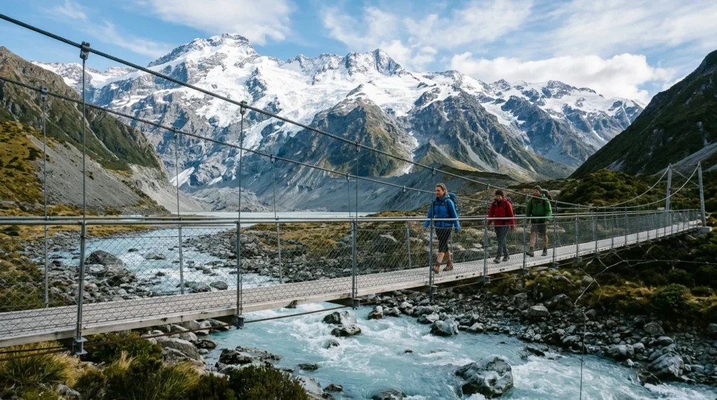
The Hooker Valley Track is a 10 kilometre return walk in Aoraki / Mount Cook National Park. The track crosses three swing bridges and ends at Hooker Lake, where icebergs often float below the mountain. The walk takes three to four hours and suits most fitness levels.
The Milford Track in Fiordland is a multi-day Great Walk. You need to book huts or guided walks well in advance, particularly for summer. The track passes through rainforest, alpine passes and alongside waterfalls.
The Routeburn Track links Fiordland and Mount Aspiring national parks. This Great Walk can be completed in two to three days. You walk through beech forest and above the treeline with views across mountain valleys.
Day walks around Wānaka and Queenstown in Otago provide shorter mountain experiences. Many tracks start close to town and return the same day.
North Island Volcanic Peaks
Tongariro National Park in the central North Island contains three volcanic mountains. Mount Ruapehu is the highest and an active volcano. Mount Tongariro and Mount Ngāuruhoe also remain active.
The Tongariro Alpine Crossing is a 19.4 kilometre one-way walk that crosses volcanic terrain. You pass emerald lakes, steam vents and volcanic craters. The walk takes seven to eight hours and requires good fitness. Weather conditions can be severe, even in summer. Transport must be arranged as the track is one-way.
The park holds UNESCO World Heritage status for both its natural features and cultural significance to Māori. The mountains are tapu (sacred) to Ngāti Tūwharetoa.
Mount Taranaki in Taranaki is a standalone volcanic cone on the west coast. The mountain is visible from much of the region on clear days. Several walking tracks circle the mountain or climb toward the summit.
Skiing and Snowboarding
Commercial ski areas operate on both islands. Queenstown and Wānaka in Otago serve multiple ski fields. The Remarkables and Coronet Peak are closest to Queenstown. Cardrona and Treble Cone operate near Wānaka.
Mount Ruapehu has two commercial ski areas on its slopes. Whakapapa operates on the northwestern side, Tūroa on the southwestern. The ski season typically runs from June to October, depending on snow conditions.
Club ski fields offer a different experience. These member-operated areas have fewer facilities but often better snow and fewer crowds. Many are located in Canterbury.
Check conditions before travelling. Snow cover varies between seasons and mountains can close due to weather or volcanic activity.
Climbing and Mountaineering
Aoraki / Mount Cook draws experienced climbers from around the world. The mountain requires technical climbing skills and mountain experience. Most climbers hire certified guides. The Alpine Guides company operates from Mount Cook Village.
The climbing season runs from November to March. Even in summer, conditions are serious. Climbers need to be prepared for rapidly changing weather, crevasses and avalanche risk.
Lower peaks in the Southern Alps offer climbs for those building experience. Mount Aspiring is a popular objective for intermediate mountaineers. Rock climbing areas exist throughout both islands, from seaside crags to alpine faces.
The New Zealand Mountain Safety Council provides training and information. Anyone heading into alpine areas should understand route planning, avalanche awareness and emergency procedures.
Wildlife and Plants
Native birds live in and around the mountains. The kea, an alpine parrot, inhabits South Island mountain areas. These intelligent birds are curious and often approach people. Do not feed them as human food is harmful.
The whio, or blue duck, lives along fast-flowing mountain rivers. The birds are endangered and protected. Rock wrens inhabit the alpine zone above the treeline.
Alpine plants include mountain daisies, buttercups and the Mount Cook lily. Many species grow nowhere else. Stick to formed tracks to avoid damaging fragile alpine vegetation.
The Department of Conservation works to control introduced pests like stoats, rats and possums that threaten native species. Visitors can help by cleaning boots between walks and following biosecurity guidelines.
Getting There and Staying Safe
State highways reach most mountain areas. The road to Aoraki / Mount Cook Village is sealed but remote. Milford Sound is accessed via the Milford Road from Te Anau. Mountain roads can close in winter due to snow or avalanche risk.
InterCity and other bus companies run scheduled services to major mountain destinations. Many walkers use shuttle services for one-way tracks like the Tongariro Alpine Crossing.
Accommodation options range from Department of Conservation campsites to hotels. Huts on multi-day tracks must be booked through the DOC website. Booking is essential for Great Walks during peak season.
Mountain weather changes rapidly. Check forecasts before departing and carry extra warm and waterproof clothing. The MetService provides detailed mountain forecasts.
Tell someone your plans and expected return time. Carry a first aid kit, map, food and water. Cell phone coverage is limited in mountain areas. Personal locator beacons can be hired from many outdoor shops and visitor centres.
In an emergency, call 111. If there is no cell coverage, activate your personal locator beacon or continue to a place where you can call for help.
For activities and adventure options throughout the mountains, check operator credentials and booking requirements in advance. Accommodation near popular areas fills quickly in summer.
FAQ
When is the best time to visit New Zealand’s mountains?
Summer (December to February) offers the most stable weather for walking and climbing. Winter (June to September) is ski season. Spring and autumn have fewer visitors but weather is less predictable. High-altitude areas can experience snow any month of the year.
Do I need a guide for mountain activities?
Day walks on formed tracks like the Hooker Valley Track or Tongariro Alpine Crossing do not require guides, though you must be prepared for alpine conditions. Technical climbing, glacier travel and mountaineering require proper training and usually a guide unless you have significant experience. Winter climbing always requires advanced skills.
Are there entry fees for national parks?
Entry to Department of Conservation land is free for New Zealand residents. International visitors may need to pay hut fees for overnight stays on Great Walks and some other multi-day tracks. Day walk car parks are usually free, though some have parking fees. Check the DOC website for current requirements.
Sources

Independent New Zealand travel guides from 0 Digital, Aotearoa New Zealand. Details change, so check with the operator or the official source before you go. Spotted something out of date? Tell us.
 Attractions
 Attractions
 Attractions
